The background of this area should be an image. Please use Change Background feature to change the background of this area.
(Can be found under DESIGN tab)
Hiking Las Vegas Blog
|
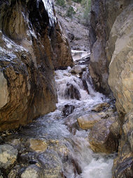
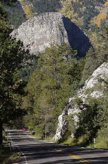
June is one of the best months to hike in Mt. Charleston. The days are long and the Monsoon season is still a month away. Dress in layers to keep comfortable. Bring a Camelbak or similar type of a daypack to stay hydrated. I suggest starting with the lower elevation trails in May and June, since Charleston received a lot of snow this winter. Hiking poles are a big help in Mt. Charleston Here Are Some Great Starter Hikes in Mt. Charleston:  Hike: Fletcher Canyon — up and back Trailhead: North side of State Route 157 — marked Distance: 4 miles (round trip) Elevation gain: 300 feet Time: 2 to 3 hours Difficulty: 1 How easy to follow: 1 Children: yes Driving Directions: Take US 95 north to State Route 157. Turn left onto 157 and drive 18.3 to parking on the left (south) side of the road. The marked trailhead is on the north side of the road. Comments: The trail starts out as an easy trek along the mountainside. After a mile and a half, it winds through canyon walls 100 feet high and ends at Obstacle Rock. The Hike: The well-maintained trail heads north and offers a beautiful view of rocky cliffs that lie in the distance. It soon crosses a rocky wash and continues the far side. A large tree lies across a creekbed at the end of the one-mile maintained trail. Although this marks the end of the maintained trail, the rest of the trail is easy to follow. As the trail heads NW, cliffs on both sides begin to close in. Water normally flows year-round in the adjacent creekbed. The canyon walls become tighter as the trail crosses the creekbed and travels deeper into Fletcher Canyon. The pathway turns south, empties into the creekbed, and weaves between 100-foot tall canyon walls. When the creekbed turns sharply to the north, boulder hopping becomes the best way to navigate. Water may be flowing in parts of the creekbed as you continue through the slot canyon. Up ahead the creekbed divides; continue straight. A huge boulder, named Obstacle Rock, blocks the entrance to the left fork of the creekbed. It marks the stopping point for most hikers. Water normally flows here making it a perfect place to rest and have a snack. To return: Retrace your steps. Cathedral Rock Cathedral Rock is a favorite hike of many Las Vegans. A well-marked trail leads to a summit that offers magnificent views of Kyle Canyon and the desert floor. It’s physically more demanding than Fletcher Canyon; however, the view from the top makes it worthwhile. Hike: Cathedral Rock — up and back Trailhead: Cathedral Rock picnic area — marked Distance: 3 miles — round trip Elevation gain: 1,000 feet Elevation Peak: 8,600 feet Time: 2 to 3 hours — round trip Difficulty: 2 How easy to follow: 1 Children: Yes Driving Directions: Take Highway north 95 to State route 157. Go left on 157, drive past the hairpin turn, and make a right turn into Cathedral Rock picnic area. The signed trailhead is on the west (right) side of the road. Comments: Cathedral Rock is the second most popular trail in Mt. Charleston. You can see Cathedral Rock, the huge pinnacle that looms above the Mt. Charleston Lodge, by looking at the imaginary 10 o’clock position as you approach the hairpin turn on 157. The Hike: The trail starts in a westward direction at a slight grade winding through thick patches of aspens and evergreens. It turns south and heads toward the magnificent Echo Cliffs. The Cliffs have a sheer drop of almost 800 feet. As the trail snakes west of Echo Cliffs, a side trail leads to a small seep. Water flows almost year-round, making the 100-yard walk worth the effort. Once past Echo Cliffs, the trail heads west and the grade becomes steeper as it makes its way across a slope. As you traverse the slope, you see many trees and boulders are still misplaced by an avalanche that happened years ago. The trail flattens out as it heads toward the backside of Cathedral Rock. This is the most enjoyable part of the trail, a cakewalk through a forest, and you forget that you're 8,000 feet above sea level. Save your energy for the last quarter mile of the trail-it's steep. Take the signed right fork when the trail divides. About a half- dozen switchbacks take you to the top of Cathedral Rock. Once on top the view becomes more spectacular with every step. Mt. Charleston Lodge lies 800 feet below and farther to the east you can see the desert floor. To the north is Mummy Mountain; to the NW is Mary Jane Falls, and to the west is Charleston Peak, the highest peak in southern Nevada. To Descend: Retrace your steps. Although, the hikes I wrote about in this article are very safe, it's wise to hike with a group of four or more, and always tell someone where you are going. If you are an advance hiker, check out the 52 Peak Club today. |
AuthorBranch Whitney is the author of Hiking Las Vegas and creator of the 52 Peak Club where members hike to the best 52 Peaks around Las Vegas, NV Archives
October 2023
Categories |

 RSS Feed