
The background of this area should be an image. Please use Change Background feature to change the background of this area.
(Can be found under DESIGN tab)
|
It's getting warmer in Las Vegas. Warm weather can zap your energy and that's when you can make a mistake and get hurt. Here are my tips for staying cool when hiking in warmer weather. 1. Bring lots of water and drink it! Dehydration can zap your thinking faster than 10 shots of moonshine! Seriously, if you are dehydrated your ability to make good decisions are gone along with your balance and coordination. How much water? It depends on how long the hike is and how hot it is. Tips: Put ice in your bladder, water container etc. the morning of your hike. Your water will stay cold and you will drink more. If it's a up and back hike, you can cache water on the ascent and pick it up on the descent and drink. Most fruit contains lots of water. 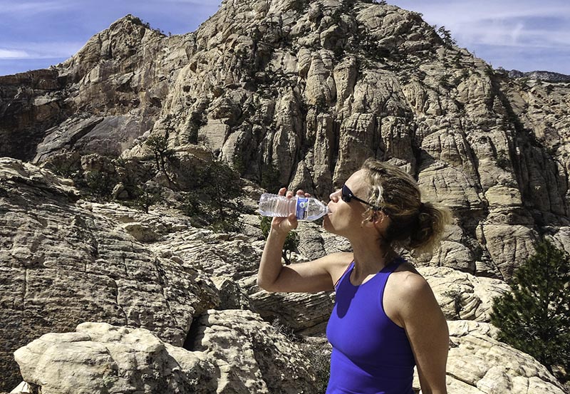 2. Black is for nightclubs, not hiking. Black or dark color clothing retains heat and that's the last thing you want when it's hot. Wear light color clothing. Tip: Wear cotton is has a cooling effect.  3. Do hikes that have shade. You can't control the sun, but you can do hikes that have a lot of shade. This will keep you significantly cooler. Tip: Kraft Mtn, West route, Oak Creek Overlook, and Las Vegas Overlook aka The Muffin Boulders are hikes that have early morning shade. These hikes are in Red Rock Canyon.  4. Get an early start. It's much cooler in the morning than the afternoon. The hottest part of the day is around 5 pm. Tip: Red Rock Canyon opens at 6 am year round.  Let's first define the hike. I am talking about a tough hike. A hike that takes 5+ hours or/and that is tough on the body, meaning a lot of twisting and squeezing through tight places. I am not talking about a trail hike here! I am writing about a rock scrambling or mountaineering hikes.  Show Me the Tips!Tip 1: Soak in a Jacuzzi. The hot water keeps your muscles loose. This is actually easy and feels good. Most gyms have a Jacuzzi.  Tip 2: Go to the gym and stretch after the hike. This will help keep your muscles loose. Yes, you can do this at home, but the question is: Will you? Once at the gym it's harder to blow off stretching. Tip 3: Movement. Once at home move. Now, I am not talking about running a marathon, but do not sit down and watch TV all night. Clean out your pack. Feed the animals, go for a short walk, anything that gets you moving. Why do this? It's very hard for muscle to get tight if you move. The body is meant to move, not sit still all day.  Tip 4: Workout or do an easy hike the next day. I am not talking about a killer workout, but a workout that gets your body moving. If you prefer to hike, make it an easy hike. A few hours at the most and it could be a trail hike. Your Goal Is LongevityIf you enjoy hiking and want to do it for 20, 30, or 40 more years, then your goal should be longevity.
Ask yourself: Is what I am doing increasing or decreasing my hiking life? You will know the answer. That's the easy part. The hard part is... Are you going to make the smart choice? Here's a great article about the top 50 long distance hikes in the US. Read it here. How tough are you? If you’re tired of the same easy trails and long for a greater sense of adventure then we’ve got a treat for you – five of the toughest hikes in the SW. These trails will give you a real test, just be sure you’re physically up to the challenge, have suitable gear (including the ten essentials) and are determined to take mother nature on. Try these hikes and find out how tough you really are: 1. Mummy Head to Toe It's a traverse across Mummy Mtn in Mt. Charleston, which is near Las Vegas, NV. During the adventure you will stand on four different peaks. Stats: Distance: 8.5 miles Elevation gain: 4,129 feet Elevation of peaks: Mummy’s Forehead 11,040, Mummy’s Chin 11,037 feet, Mummy’s Tummy 11,542 feet, Mummy’s Toe 10,925 feet Time: all day Class: 4+ What makes it so tough? No trail, four peaks and traversing around 11,000 feet for most of the day. (There's a five peak variation) Inside info: Watch for loose rock. A car shuttle is required. 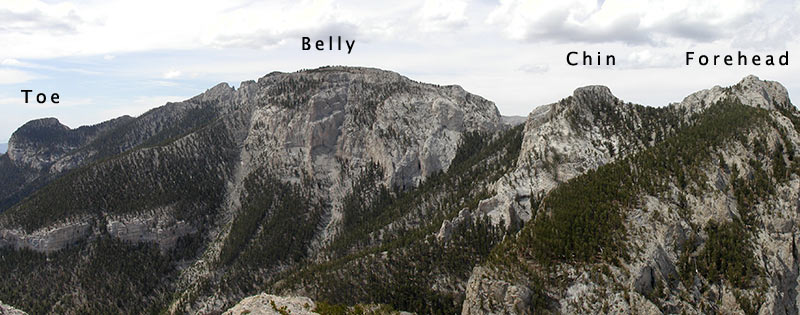 The four summits. 2. Norman Clyde One of the toughest peaks in the Sierra and named after the most prolific mountaineer of the Sierra. Stats: Distance: 13 miles – round trip Elevation gain: 6,160 feet Elevation peak: 13,920 feet Time: Long day or backpack Class: 4 What makes it so tough? It's a steep climb at high elevation and it's cold even in August. The route ascends the North Face. Inside info: Attempt in late August/early Sept. Bring gloves and rap gear. 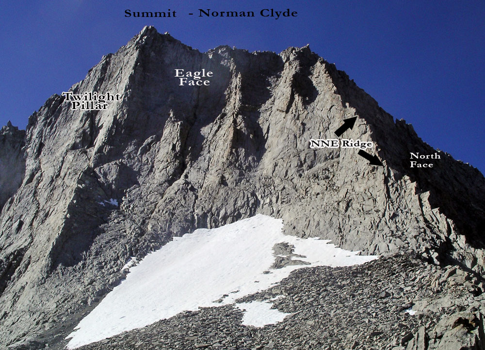 Norman Clyde 3. Four Peak Scramble in Red Rock Canyon This is possibly the toughest rock scramble in the country! With virtually no trail it's all scrambling to four very different peaks: Juniper, Gunsight Notch, Rainbow and Mt. Wilson. Each of these peaks is a good hike; all four in one day is a killer hike. Stats: Distance: 9 miles – round trip Elevation gain: 7,160 feet Elevation peak: Juniper 6,109 feet, Gunsight Notch 6,200 feet, Rainbow 6,800 feet, Mt. Wilson 7,070 feet Time: A very long day Class: 4+ What makes it so tough? Massive elevation loss after Juniper and Rainbow peaks. The toughest peak (Mt Wilson) is the last peak of the day! Inside Info: Cache water before attempting this hike. 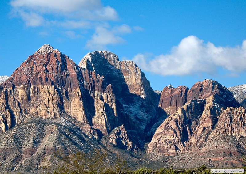 Rainbow, Gunsight Notch, and Juniper Peaks. Mt. Wilson is to the left of Rainbow Peak 4. Mt. Sill Another Sierra Peak with possibly the best vista in the Sierra! This is a very tough climb. Check out the stats below. Stats: Distance: 20 miles – round trip Elevation gain: 6,300 feet; Elevation peak: 14,136 feet Time: Long day or backpack Class: 3/4 What makes it so tough? 20 miles and 6,300 feet in gain. Do I need to say more? Inside info: Most camp at Sam Mack Meadows. This breaks up the climb. It's a trail hike to Sam Mack Meadows. 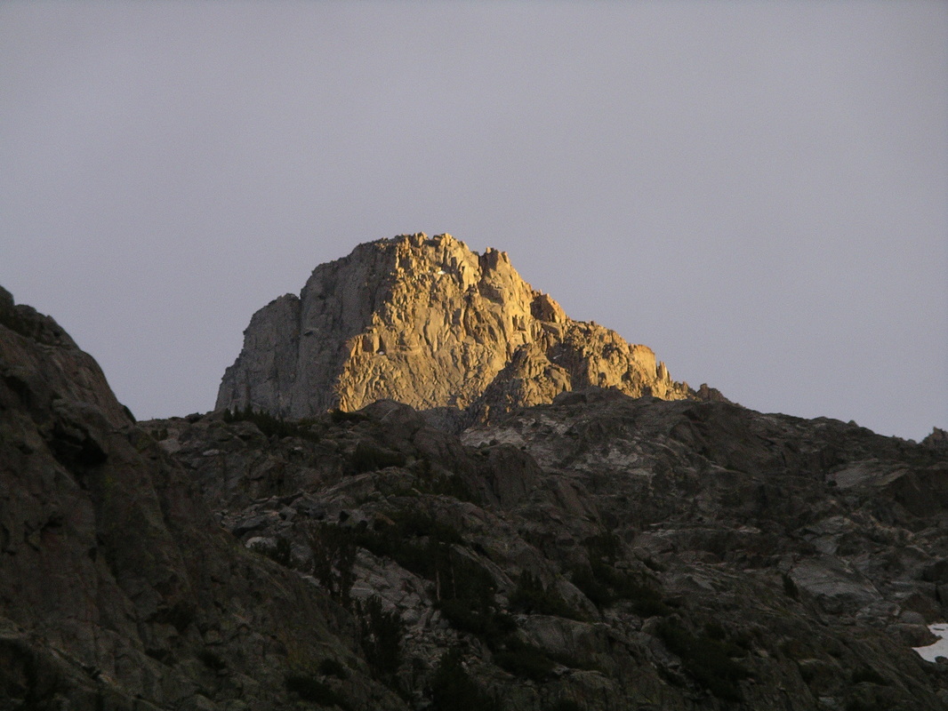 Mt. Sill 5. Badwater to Telescope Peak
Many hardcore hikers consider this the toughest hike in the country. You start at sea level and ascend to 11,049 feet! That's a lot of elevation gain. The hike is called Badwater to Telescope, but most start at Shorty's Well. It cuts out about four miles of walking across the desert in the middle of the night. Stats: Distance: 21 miles (from Shorty’s Well to Mahogany Flats Trailhead) Elevation gain: 11,300 feet Elevation peak: 11,049 feet Time: 12 to 16 hours Class: 2 What makes it so tough? Gee, do you really need me to tell you? Also, logistically this is not an easy hike. Most hikers have a car at Mahogany Flats trailhead to make the hike shorter; otherwise, you have to retrace your steps descending 11,000 feet. Inside info: Do this hike in October and start around 2 am. Bring a gps. You want to intersect the official trail at a saddle to avoid a terrible scree field. Here are five secret hikes that you probably haven't done. You will want to do these hikes after reading this article. These hikes are located in Red Rock Canyon, just 20 miles west of Las Vegas, NV. 1. Lost Creek Peak via the Ridge Route This is a crazy hike with tons of class 4 scrambling. It features the amazing Graffiti Traverse! Check out the video below. This is a long hike. Stats: Distance: 6 miles (no trail at all) Elevation gain: 2,100 feet Elevation peak: 6,644 feet Time: 6 to 7 hours Difficulty: 4 Class: 4/5 2. Tunnel Vision Peak via the Original Route After years of hikers abandoning this hike, it's back. We found a work-around the bees, which makes the hike even better! Lot's of ropes on this route and they are needed. Stats: Distance: 4 miles - Up and back Elevation gain: 1,700 feet Elevation peak: 6,100 feet Time: 5 to 6 hours Difficulty: 3 Class: 5 with ropes 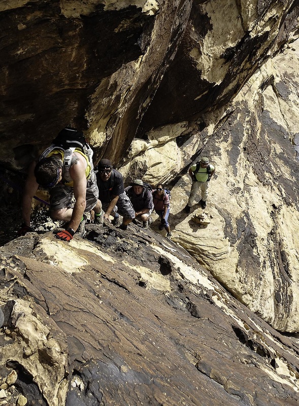 One of the many climbs on this route. 3. The Stealth Range If you have hiked in Black Velvet Canyon, you have seen these awesome looking pinnacles. At times they seem to disappear and then reappear. Each pinnacle is mind blowing. Come prepared with ropes and a harness. There are at least three raps. Stats: Distance: 7 miles - Up and back Elevation gain: 2,507 feet Elevation peaks: ~6,100 feet Time: 6 to 7 hours Difficulty: 4 Class: 4  4. South Summit of Mt. Wilson This summit is different than Mt. Wilson. It has a cool ledge just below the summit that looks straight down 2,000 feet into the void. The route first travels to White Pinnacle Peak, one of the best summits in Red Rock, but you already know this! Stats: Distance: 8 miles — up and back Elevation gain: 3,064 feet Elevation of peak: 6,791 feet Time: 6 to 8 hours - Up and back Difficulty: 5 Class: 4 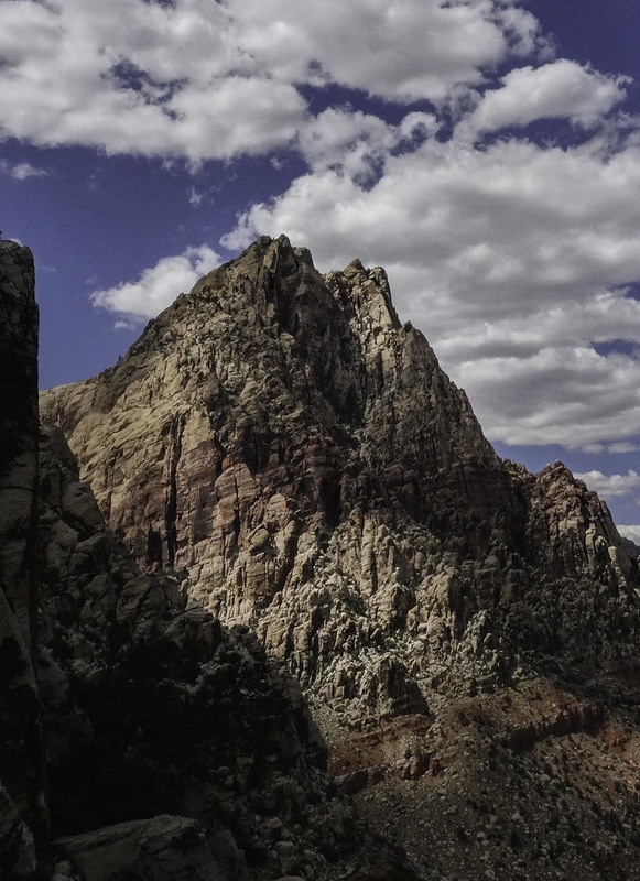 South Summit of Mt. Wilson 5. Walk Up Wall This route goes through the amazing Gunsight Notch before scaling an intimidating wall to the summit. Once at the summit you are looking at the upper part of Rainbow Wall. Stats: Distance: 7.5 miles – round trip Elevation gain: 2,550 feet Elevation peak: 6,660 feet Time: 5 to 6 hours Difficulty: 4 Class: 4 (very exposed) 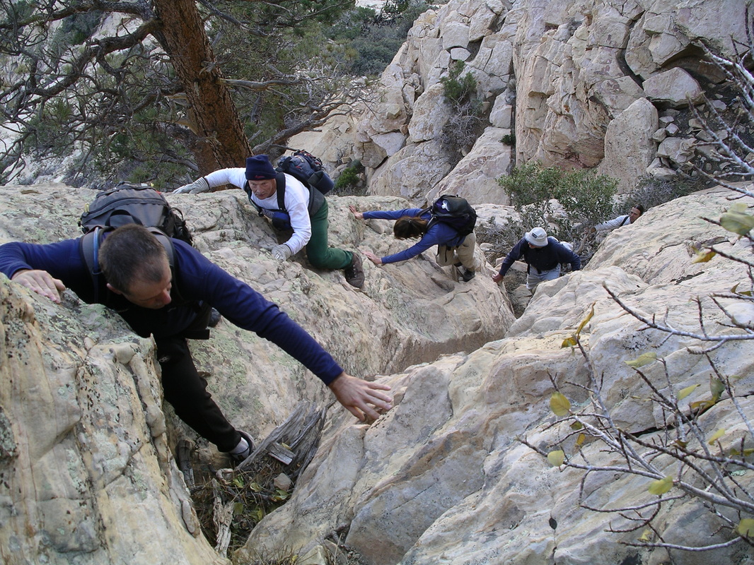 Climbing to Walk Up Wall 2 Smart Ways to Do These HikesThese hikes are very hard to follow. There's no signs, no trails to the summits. There's only one hiking group that does these hike and that's the 52 Peak Club.
If you are the type that likes to do these hikes with your hiking buddies, then you can become a VIP of this website where you can download the step by step directions with GPS waypoints. Note: The Stealth Range is not available for download at this time. All of these routes were found by the 52 Peak Club. 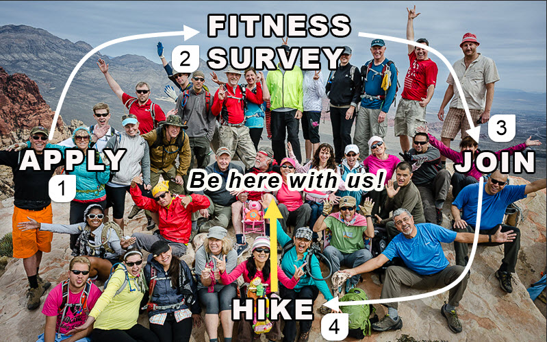 Here's how to join the 52 Peak Club Breakdown of the above graphic:
Here's what you get: You will set a worthwhile goal (climb all 52 Peaks) and achieve that goal. You will increase your fitness. You will learn about the mountains around Las Vegas. You will meet amazing people. In short, you will transform yourself. |
AuthorBranch Whitney is the author of Hiking Las Vegas and creator of the 52 Peak Club where members hike to the best 52 Peaks around Las Vegas, NV Archives
October 2023
Categories |
 RSS Feed