
Charleston Peak
STATS:
Hike: South Loop to Charleston Peak — Trail
Trailhead: Cathedral Rock picnic area — marked
Distance: 17 miles - up and back
Elevation gain: 4,055 feet
Elevation Peak: 11,918 feet
Time: 7 to 9 hours - up and back
Difficulty: 5
Class: 1
How easy to follow: 1
Children: no
Hike: South Loop to Charleston Peak — Trail
Trailhead: Cathedral Rock picnic area — marked
Distance: 17 miles - up and back
Elevation gain: 4,055 feet
Elevation Peak: 11,918 feet
Time: 7 to 9 hours - up and back
Difficulty: 5
Class: 1
How easy to follow: 1
Children: no
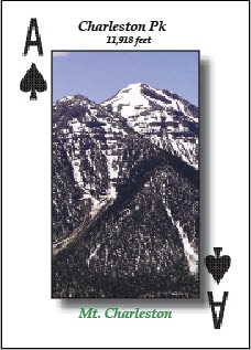
Location: Mt. Charleston
The South Loop Trail takes you to the highest point in Southern Nevada. You’re almost 10,000 feet above Las Vegas, NV. Once you reach the grassy wonderland, the hiking becomes easy. If you are into camping, this is one of the best spots in all of Mt. Charleston. The last half-mile is very strenuous, but the views from the peak make it all worthwhile.
Charleston Peak is the only treeless summit in Southern NV.